. OnHiatus.com > Journal 1 > Day Index > Journal Entry: April 29, 1997

Tuesday, April 29, 1997
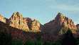
Las Vegas, Nevada to Zion National Park, Utah
US's FlagNV's FlagAZ's FlagUT's Flag

Map
Zion National Park, Utah:
Latitude: 37° 12' 12" North
Longitude: 112° 58' 45" West
Altitude: 4400 feet
From Seattle: 947 miles
Lodging: Camp - The Watchman Campground

Map
Today's Travel:
Country: United States
Regions: Nevada, Arizona, Utah
Route: I15, SR9
Path:Las Vegas, Nevada - Zion National Park, Utah
Linear:146 miles
Weather: Sunny

Available Photos:

Red cliffs Approaching Zion National Park, UT

Desert-scape Approaching Zion National Park, UT

Zion Approaching Zion National Park, UT

The Watchman Watchman Campground, Zion National Park, UT

The Watchman Watchman Campground, Zion National Park, UT

The Watchman Watchman Campground, Zion National Park, UT

All photo images © 1997-2000 Anthony Jones - Images may not be used without prior written approval.

Click on map to Zoom in...
Map
Trip Stats to Date:
Day: 19
Linear Dist: 34079
Countries Visited: 1
Regions Visited: 6
More stats...
Hotels: 2
Friends / Family: 14
Camping: 3
Beers: 66
Hide...

Journal Entry:
Lost


Paging: [⇚ Apr 28] | [Apr 30 ⇛] OnHiatus.com > Journal 1 > Day Index > Journal Entry: April 29, 1997