Wednesday July 2, 1997
Alaska Marine Highway ferry M/V Le Conte, AK to King Mountain State Park, AK
US's Flag Canada's Flag US's Flag AK's Flag AK's Flag
Current Time
GMT (+0):18:48
Seattle (-8):10:48
King Mountain State Park (-10):08:48

King Mountain State Park, AK :
Latitude:61° 46' 28" North
Longitude:148° 29' 44" West
From Seattle:1514 miles
Altitude:837 feet
Lodging:Camp - King Mountain State Park
Map

Today's Travel:
Countries:US
Canada
US
Regions:AK
British Columbia
Yukon Territory
AK
Route:Alaska Marine Highway ferry M/V Le Conte, SR7 (Haines Highway), SR4, SR3, SR1, SR2 (Alaska Highway), SR1 (Glenn Highway)
Stops:1. Haines Ferry Terminal, Haines, AK
2. Rock Glacier, Kluane National Park, YT, Canada
3. Destruction Bay, YT, Canada
4. Wrangell-St. Elias National Park, AK
Road Miles:703 miles
Linear:628 miles
Weather:Sunny / Mostly Cloudy
Map

Available Photos:
All photo images © 1997-2000 Anthony Jones
Images may not be used without prior written approval.
Photo
Subject:Morning light on mountains above Haines
Location:Haines, AK
Larger image available
Photo
Subject:Bald Eagle
Location:Near Haines (Mile marker 7), AK
Larger image available
Photo
Subject:Bald Eagle
Location:Near Haines (Mile marker 7), AK
Larger image available
Photo
Subject:Bald Eagle, wings spread
Location:Near Haines (Mile marker 7), AK
Larger image available
Photo
Subject:Bald Eagles: 1 in flight, 1 perched
Location:Near Haines (Mile marker 7), AK
Photo
Subject:Tatshenshini-Alsek Wilderness at Historic Mile 48
Location:Tatshenshini-Alsek Wilderness Provincial Park, BC, Canada
Photo
Subject:Edge of Rock Glacier
Location:Rock Glacier trail, Kluane National Park, YT, Canada
Larger image available
Photo
Subject:Purple flowers
Location:Rock Glacier trail, Kluane National Park, YT, Canada
Larger image available
Photo
Subject:Remains of Rock Glacier's body
Location:Rock Glacier trail, Kluane National Park, YT, Canada
Larger image available
Photo
Subject:Lake and island in morning sun from Rock Glacier
Location:Rock Glacier trail, Kluane National Park, YT, Canada
Larger image available
Photo
Subject:Lichens on a rock
Location:Rock Glacier trail, Kluane National Park, YT, Canada
Larger image available
Photo
Subject:Bark
Location:Rock Glacier trail, Kluane National Park, YT, Canada
Larger image available
Photo
Subject:Lake Kluane
Location:Alaskan Highway, YT, Canada
Photo
Subject:Vanishing mountains
Location:Wrangell-St. Elias National Park, AK
Photo
Subject:Trees and storm
Location:Wrangell-St. Elias National Park, AK
Photo
Subject:The sun breaks through on one of Wrangell-St. Elias National Park's peaks
Location:Wrangell-St. Elias National Park, AK
Photo
Subject:The sun breaks through on an other of Wrangell-St. Elias National Park's peaks
Location:Wrangell-St. Elias National Park, AK
Photo
Subject:One of Wrangell-St. Elias National Park's peaks
Location:Wrangell-St. Elias National Park, AK
Larger image available
Photo
Subject:? Glacier
Location:~Mile 90, Alaskan Highway, AK
Larger image available
Photo
Subject:Midnight (!) view of King Mountain, out my tent door
Location:King Mountain State Park, AK

Trip to Date:
Day:83
Miles Driven:17103
Linear Dist:13515
Countries Visited:2
Regions Visited:38
Nights in Hotels:30
Nights with Friends / Family:24
Nights Camping:18
Nights in Hostels:7
Nights in Transit:4
Beers:244
Map

Entry:
On future ferries get a lounge on the Solarium! This is the only way to go, fresh air, not to cold, lot's of white noise from the wake, and stars.

The ferry landed at Haines at about 4:15am, so I was on my way well before five. Haines seemed pretty boring so I didn't wait around for anything to open. Just North of town there is a lake where Bald Eagles hunt. There must have been at least 100 eagles there at one time. It was incredible. I stopped and watched them hunt for awhile. I got to the border about 6a, unfortunately the border doesn't open until 7am.

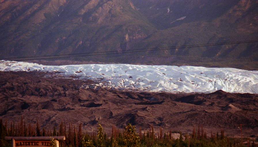
After waiting for the BC border to open I drove a couple hours to Kluane National Park in the Yukon Territory, Canada. I went for a short hike up to Rock Glacier, which is (strangely enough) a rock glacier as opposed to an ice glacier. The hike wasn't very challenging, but I needed to get out of the car. I did see some bear tracks that couldn't have been much more than an hour old, no bears though. I stopped for lunch in Destruction Bay which is on Lake Kluane.

After many more hours of driving I saw lightning ahead, so I stopped to put the top up. Within five minutes of starting back up I was in some of the hardest rain I'd ever seen. I'd been planning on camping at Wrangell-St. Elias National Park (the nations largest national park), but the campsites didn't look that inviting in the storm, so I opted to continue on after looking around.

I found a great campsite in King Mountain State park, which is about 80 miles from Anchorage. The camp site is on the river, under King Mountain. The view is great, even now in the broad daylight at 12:30am! It never gets dark here!


[Previous Day] | [Index] | [Next Day]

Back To: Welcome Page