-
Wednesday, July 28, 1999
-
Chefchaouen, Morocco
|
| Chefchaouen, Morocco: | |||||||||||
|
|||||||||||
| Today's Travel: | |||||||
|
|||||||
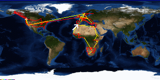
| Trip Stats to Date: | |||||||||||||||||||||||||||
|
|||||||||||||||||||||||||||
I checked email then met up with Amy to go shopping in the medina. We wandered around a bit, but I just wasn't in the mood and couldn't be bothered to look at anything so we ended up sitting in a cafe on the square. Walked back to the house and had omelet sandwiches with the leftover salsa and goat cheese.

