. OnHiatus.com > Journal 1 > Day Index > Journal Entry: August 30, 1999

Monday, August 30, 1999
Laguna Beach to San Francisco, California
US's FlagCA's Flag

Map
San Francisco, California:
Latitude: 37° 45' 23" North
Longitude: 122° 27' 52" West
Altitude: 572 feet
From Seattle: 778 miles
Lodging: Friend / Family - Wolf

Map
Today's Travel:
Country: United States
Region: California
Route: Reno Air Flight ?: Orange County - San Francisco
Path:Laguna Beach - San Francisco, California
Linear:421 miles
Weather: Mostly Sunny

Click on map to Zoom in...
Map
Trip Stats to Date:
Day: 872
Linear Dist: 164634
Countries Visited: 60
Regions Visited: 241
More stats...
Hotels: 275
Friends / Family: 190
Camping: 118
Hostels: 218
Transit: 57
Other Lodging: 13
Beers: 3242
Hide...

Journal Entry:
Tomoko and I caught a mid-morning flight to San Fransico - on Reno's last day as an airline. Caught a taxi to Wolf's place then walked around the Marina district and had lunch with Tomoko.

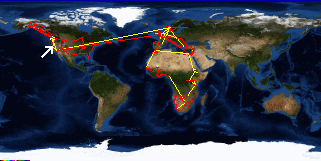
Spent the afternoon with my travel agent buying tickets. It took a long time and cost me a lot of money but I now have my very unorthadox route to Sydney (via Key West, New Yourk City, Iceland, Morocco, Mauritius, Madagascar, Singapore and Bali).

Had diner with Wolf and Tomoko, and Wendy and Bunny showed up for a bit.


Paging: [⇚ Aug 23] | [Aug 31 ⇛] OnHiatus.com > Journal 1 > Day Index > Journal Entry: August 30, 1999