. OnHiatus.com > Journal 1 > Day Index > Journal Entry: December 27, 1999

Monday, December 27, 1999
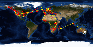
Jillaby to Blackhead (Hallidays Point), Australia
Australia's FlagNew South Wales's Flag

Map
Blackhead (Hallidays Point), Australia:
Latitude: 32° 0' 0" South
Longitude: 152° 30' 0" East
Altitude: 236 feet
From Seattle: 8551 miles
Lodging: Friend / Family - Susie's Parents

Map
Today's Travel:
Country: Australia
Region: New South Wales
Path:Jillaby - Blackhead (Hallidays Point), Australia
Linear:141 miles
Weather: Overcast / Rain

Click on map to Zoom in...
Map
Trip Stats to Date:
Day: 991
Linear Dist: 198509
Countries Visited: 67
Regions Visited: 250
More stats...
Hotels: 324
Friends / Family: 248
Camping: 120
Hostels: 220
Transit: 65
Other Lodging: 13
Beers: 3513
Hide...

Journal Entry:
Woke up and could hardly move - I'm so sore that I move like I'm 90 years old! Had a huge breakfast then headed for Susie's Parent's holiday house out on the coast. It should have been a two hour drive, but ended up being nearly four and a half thanks to the hideous traffic. All the time sitting in the car wasn't kind to my back.

At the beach house the weather took a nasty turn to rain. Tried to take the dog for a walk on the beach but gave up pretty quickly. Walked up to the bowling club to play the pokies (poker machines). Actually walked away $55 up! Spent the night playing cards ("Oh Hell" - a variation of 500), having dinner, and staying up late playing Balderdash.


Related Sites:
US State Department Consular Information Sheets: Australia
CIA World Fact Book: Australia

Paging: [⇚ Dec 26] | [Dec 28 ⇛] OnHiatus.com > Journal 1 > Day Index > Journal Entry: December 27, 1999