. OnHiatus.com > Journal 1 > Day Index > Journal Entry: December 29, 1999

Wednesday, December 29, 1999
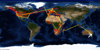
Blackhead (Hallidays Point) to Sydney, Australia
Australia's FlagNew South Wales's Flag

Map
Sydney, Australia:
Latitude: 33° 53' 7" South
Longitude: 151° 14' 2" East
Altitude: 236 feet
From Seattle: 8714 miles
Lodging: Friend / Family - Susie

Map
Today's Travel:
Country: Australia
Region: New South Wales
Path:Blackhead (Hallidays Point) - Sydney, Australia
Linear:165 miles
Weather: Partial Sun / Rain / Overcast

Click on map to Zoom in...
Map
Trip Stats to Date:
Day: 993
Linear Dist: 198674
Countries Visited: 67
Regions Visited: 250
More stats...
Hotels: 324
Friends / Family: 250
Camping: 120
Hostels: 220
Transit: 65
Other Lodging: 13
Beers: 3523
Hide...

Journal Entry:
Back is finally starting to feel better. Woke up to mostly blue skies so we headed for the beach. Somewhat predictably it started to rain hard just after we got there. Back at the house I took a nap and then we packed for the drive back to Sydney.

Back in the city Susie and I decided to watch Friends on tape - or rather I wanted to get caught up on the series and Susie agreed to borrow the tapes for me and watch them with me (I'm about three seasons behind now). We ordered Mexican take out (not stunning, but not bad), and watched eight episodes.


Related Sites:
CNN: Current Weather in Sydney
US State Department Consular Information Sheets: Australia
CIA World Fact Book: Australia

Paging: [⇚ Dec 28] | [Dec 30 ⇛] OnHiatus.com > Journal 1 > Day Index > Journal Entry: December 29, 1999