Sunday July 14, 2002
Anguar, Palau
Palau's Flag
Current Time
GMT (+0):16:26
Seattle (-8):08:26
Anguar (+9):01:26

Anguar, Palau :
Latitude:6° 54' 9" North
Longitude:134° 7' 54" East
From Seattle:7097 miles
Altitude:14 feet
Lodging:Hotel - Leon's Guest House
Map

Today's Travel:
Country:Palau
Region:Anguar
Weather:Sunny
Map

Available Photos:
All photo images © 1997-2000 Anthony Jones
Images may not be used without prior written approval.
Photo
Subject:Northern coast
Location:Anguar, Palau
Larger image available
Photo
Subject:Sue on rocks
Location:Anguar, Palau
Larger image available
Photo
Subject:Blow hole
Location:Anguar, Palau
Larger image available
Photo
Subject:Landing craft wreckage on beach
Location:Red Beach, Anguar, Palau
Larger image available
Photo
Subject:Landing craft wreckage on beach
Location:Red Beach, Anguar, Palau
Larger image available
Photo
Subject:Landing craft wreckage on beach
Location:Red Beach, Anguar, Palau
Larger image available
Photo
Subject:Propeller on beach
Location:Red Beach, Anguar, Palau
Larger image available
Photo
Subject:Mini island
Location:Red Beach, Anguar, Palau
Larger image available
Photo
Subject:Stacy and Sue beach combing
Location:Red Beach, Anguar, Palau
Larger image available
Photo
Subject:Propeller and reflections
Location:Red Beach, Anguar, Palau
Larger image available
Photo
Subject:Rock and reflections
Location:Red Beach, Anguar, Palau
Larger image available
Photo
Subject:Propeller and reflections
Location:Red Beach, Anguar, Palau
Larger image available
Photo
Subject:Propeller and reflections
Location:Red Beach, Anguar, Palau
Larger image available
Photo
Subject:Surf and reflections
Location:Red Beach, Anguar, Palau
Larger image available
Photo
Subject:Surf and reflections
Location:Red Beach, Anguar, Palau
Larger image available
Photo
Subject:Surf and reflections
Location:Red Beach, Anguar, Palau
Larger image available
Photo
Subject:Sunset
Location:Dock, Anguar, Palau
Larger image available
Photo
Subject:Sunset
Location:Dock, Anguar, Palau
Larger image available
Photo
Subject:Turtle on surface
Location:Dock, Anguar, Palau
Larger image available

Trip to Date:
Day:32
Linear Dist:8993
Countries Visited:3
Regions Visited:6
Nights in Hotels:9
Nights with Friends / Family:19
Nights Camping:1
Nights in a Hospital:2
Beers:68
Click on map to Zoom in...
Map

Entry:
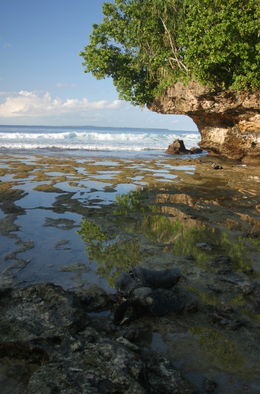
Stacy and Sue went to Mass while I stayed at the house and worked on my journal. When they got back I had breakfast and found out that they'd been invited to a local feast tonight. We all felt pretty lazy, so we sat around reading until lunch. Not sure if we were all still feeling the effects of yesterdays long walk, or maybe it was just the heat - or maybe just the island. In the afternoon walked up to the north end of the island. We found and explored some ruins (no idea what it once was, but a stone building and some kind of monument was in what might have been a formal garden. We wandered through the abandoned US Coast Guard station to the rugged coast. We decided to follow the coast to the beach we wanted to go to. Maybe not the brightest idea as we were soon climbing around the sharp drop-offs - not a fun task given that the rock is all razor sharp old coral. Eventually we got to Red Beach where I spent a while exploring the many ruined landing craft ("Red" refers to the color of the water when the US Army was landing in W.W.II). We ended up spending the rest of the day beach combing and then had to rush to make the sunset off the jetty again. The sunset was better than last night, but the horizon was still cloudy.


[Previous Day] | [Index] | [Next Day]

Back To: Welcome Page