. OnHiatus.com > Journal 1 > Day Index > Journal Entry: May 31, 2000

Wednesday, May 31, 2000
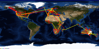
Torquay, Hervey Bay to Kingfisher Bay, Fraser Island, QLD, Australia
Australia's FlagQueensland's Flag

Map
Kingfisher Bay, Fraser Island, QLD, Australia:
Latitude: 25° 23' 30" South
Longitude: 153° 1' 52" East
Altitude: 131 feet
From Seattle: 8093 miles
Lodging: Hotel - Kingfisher Bay

Map
Today's Travel:
Country: Australia
Region: Queensland
Route: Ferry: Mary River Heads - Fraser Island
Start: Torquay, Hervey Bay
Stop 1. Mary River Heads
End:Kingfisher Bay, Fraser Island, QLD, Australia
Road Miles:63 miles
Linear:19 miles
Weather: Sunny

Click on map to Zoom in...
Map
Trip Stats to Date:
Day: 1147
Miles Driven:185777
Linear Dist: 218591
Countries Visited: 68
Regions Visited: 259
More stats...
Hotels: 385
Friends / Family: 293
Camping: 126
Hostels: 256
Transit: 73
Other Lodging: 13
Beers: 4027
Hide...

Journal Entry:
Up early when most of the people in my dorm got up at five to leave for a tour. Goofed off until the ferry ride to Fraser. Stopped at Kingfisher Bay Resort to look around the posh grounds. Walked down to the beach then had a beer while looking at the guide books to try and plan where to go. Predictably ended up staying the night.


Related Sites:
US State Department Consular Information Sheets: Australia
CIA World Fact Book: Australia

Paging: [⇚ May 30] | [Jun 1 ⇛] OnHiatus.com > Journal 1 > Day Index > Journal Entry: May 31, 2000