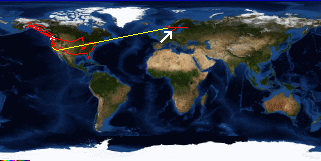
The plan was for me to head down to Frankfurt Germany, while Sof was going to go to Hamburg. We knew what time the train was supposed to get there, we knew what spur. The train got there we got on, and instead of ending up in Hamburg 5.5 hours later, we ended up far to the North. No idea how we got on the wrong train, wil always ask the conductor from now on.
Now the fasted way to get to Germany involves going via Copenhagen, so we get on the train back to Copenhagen. On the train I decide I'm not going to go to Germany now, since I have to be in Copenhagen on Friday to catch a plane. So it's indulgence time since aa whole day has been wasted on the train, it's late, and I'm starving. A chicken ceasar at the Hard Rock Cafe, a taxi out of town, and it's back at the hostel.