Photos from roll of film 561-510
All photo images © 1997-2002 Anthony Jones
Images may not be used without prior written approval.
Last Itinerary |
Bibliography |
Useful Travel Links |
My Travel Statement
Index Views:
By Date |
By Country |
By Photo |
By Film Rolls |
By Date (text) |
By Photo (text)
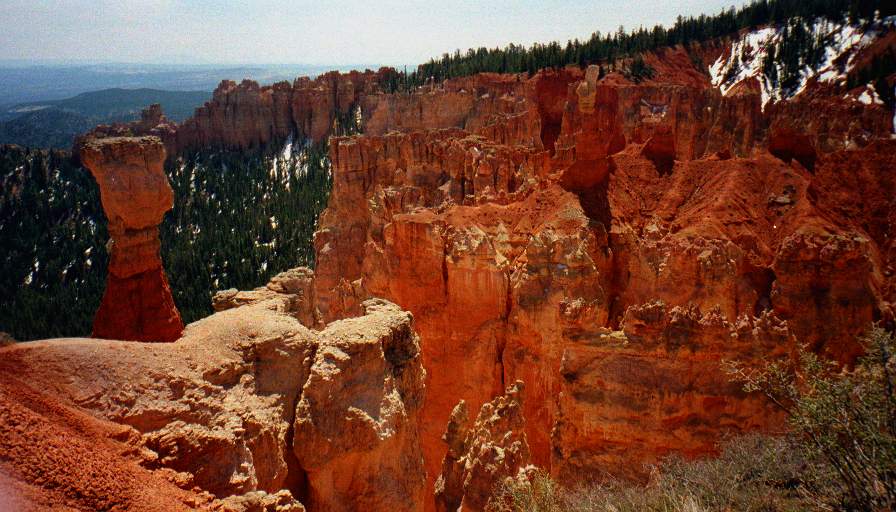
 "Natural Bridge" Arch
Bryce National Park, UT
Time: 1141MDT, May 2, 1997
Frame 1 of 25 on roll 561-510; Camera: Cannon Elph; Film speed: ISO200
1. "Natural Bridge" Arch
Bryce National Park, UT
May 2, 1997

 Hoodoo
Natural Bridge Trail, Bryce National Park, UT
Time: 1142MDT, May 2, 1997
Frame 2 of 25 on roll 561-510; Camera: Cannon Elph; Film speed: ISO200
2. Hoodoo
Natural Bridge Trail, Bryce National Park, UT
May 2, 1997
4. Rainbow Point View
Rainbow Point, Bryce National Park, UT
May 2, 1997

 "Molly's Nipple"
Yovimpa Point, Bryce National Park, UT
Time: 1212MDT, May 2, 1997
Frame 5 of 25 on roll 561-510; Camera: Cannon Elph; Film speed: ISO200
5. "Molly's Nipple"
Yovimpa Point, Bryce National Park, UT
May 2, 1997
 Navajo Mountain (w/ 200 mile visibility)
Yovimpa Point, Bryce National Park, UT
Time: 1213MDT, May 2, 1997
Frame 6 of 25 on roll 561-510; Camera: Cannon Elph; Film speed: ISO200
6. Navajo Mountain (w/ 200 mile visibility)
Yovimpa Point, Bryce National Park, UT
May 2, 1997
 White Cliffs
Paria Point, Bryce National Park, UT
Time: 1248MDT, May 2, 1997
Frame 7 of 25 on roll 561-510; Camera: Cannon Elph; Film speed: ISO200
7. White Cliffs
Paria Point, Bryce National Park, UT
May 2, 1997
 Hoodoo and structures
Paria Point, Vertide Panorama, Bryce National Park, UT
Time: 1249MDT, May 2, 1997
Frame 8 of 25 on roll 561-510; Camera: Cannon Elph; Film speed: ISO200
8. Hoodoo and structures
Paria Point, Vertide Panorama, Bryce National Park, UT
May 2, 1997
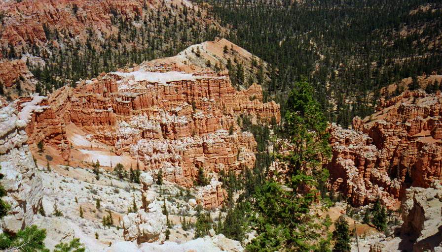
9. Rock Structure
Near Bryce Point, Bryce National Park, UT
May 2, 1997
 Panoramic View
Bryce Point, Bryce National Park, UT
Time: 1302MDT, May 2, 1997
Frame 10 of 25 on roll 561-510; Camera: Cannon Elph; Film speed: ISO200
10. Panoramic View
Bryce Point, Bryce National Park, UT
May 2, 1997
 "The Arch" and surrounding grottos
Bryce Point, Bryce National Park, UT
Time: 1304MDT, May 2, 1997
Frame 11 of 25 on roll 561-510; Camera: Cannon Elph; Film speed: ISO200
11. "The Arch" and surrounding grottos
Bryce Point, Bryce National Park, UT
May 2, 1997
 Mesas
Mesas
Bryce Point, Bryce National Park, UT
Time: 1311MDT, May 2, 1997
Frame 12 of 25 on roll 561-510; Camera: Cannon Elph; Film speed: ISO200
12. Mesas
Bryce Point, Bryce National Park, UT
May 2, 1997
 Sand Dunes and Mesa
Coral Pink Sand Dunes State park, UT
Time: ?, May 2, 1997
Frame 13 of 25 on roll 561-510; Camera: Cannon Elph; Film speed: ISO200
13. Sand Dunes and Mesa
Coral Pink Sand Dunes State park, UT
May 2, 1997
 Shadow at top of dune
Coral Pink Sand Dunes State park, UT
Time: 1533MDT, May 2, 1997
Frame 14 of 25 on roll 561-510; Camera: Cannon Elph; Film speed: ISO200
14. Shadow at top of dune
Coral Pink Sand Dunes State park, UT
May 2, 1997
 Sand
Sand
Coral Pink Sand Dunes State park, UT
Time: 1540MDT, May 2, 1997
Frame 15 of 25 on roll 561-510; Camera: Cannon Elph; Film speed: ISO200
15. Sand
Coral Pink Sand Dunes State park, UT
May 2, 1997
 My Path
Coral Pink Sand Dunes State park, UT
Time: 1546MDT, May 2, 1997
Frame 16 of 25 on roll 561-510; Camera: Cannon Elph; Film speed: ISO200
16. My Path
Coral Pink Sand Dunes State park, UT
May 2, 1997
 "The Vermilion Cliffs"
US89A, AZ
Time: 1840MST, May 2, 1997
Frame 18 of 25 on roll 561-510; Camera: Cannon Elph; Film speed: ISO200
18. "The Vermilion Cliffs"
US89A, AZ
May 2, 1997
19. The Trailhead
South Kaibab Trailhead, Grand Canyon National Park, AZ
May 3, 1997
20. View from below rim
South Kaibab Trail, Grand Canyon National Park, AZ
May 3, 1997
 View #2 from below rim
South Kaibab Trail, Grand Canyon National Park, AZ
Time: 1214MST, May 3, 1997
Frame 21 of 25 on roll 561-510; Camera: Cannon Elph; Film speed: ISO200
21. View #2 from below rim
South Kaibab Trail, Grand Canyon National Park, AZ
May 3, 1997
22. First glimpse of the Colorado
Just below the start of the Supai formation, South Kaibab Trail, Grand Canyon National Park, AZ
May 3, 1997
 The River
South Kaibab Trail, Grand Canyon National Park, AZ
Time: 1336MST, May 3, 1997
Frame 23 of 25 on roll 561-510; Camera: Cannon Elph; Film speed: ISO200
23. The River
South Kaibab Trail, Grand Canyon National Park, AZ
May 3, 1997
 Out buildings of Phantom Ranch
Panorama Point, South Kaibab Trail, Grand Canyon National Park, AZ
Time: 1346MST, May 3, 1997
Frame 24 of 25 on roll 561-510; Camera: Cannon Elph; Film speed: ISO200
24. Out buildings of Phantom Ranch
Panorama Point, South Kaibab Trail, Grand Canyon National Park, AZ
May 3, 1997
 North Rim
Panorama Point, South Kaibab Trail, Grand Canyon National Park, AZ
Time: 1347MST, May 3, 1997
Frame 25 of 25 on roll 561-510; Camera: Cannon Elph; Film speed: ISO200
25. North Rim
Panorama Point, South Kaibab Trail, Grand Canyon National Park, AZ
May 3, 1997
