. OnHiatus.com > Journal 1 > Day Index > Journal Entry: August 19, 1998

Wednesday, August 19, 1998
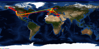
Tangier to Rabat, Morocco
Morocco's Flag

Map
Rabat, Morocco:
Latitude: 34° 1' 2" North
Longitude: 6° 50' 3" West
Altitude: 95 feet
From Seattle: 6085 miles
Lodging: Hotel - Hotel Velleda

Map
Today's Travel:
Country: Morocco
Regions: The Mediterranean Coast, The Atlantic Coast
Route: Train: Tangier - Sidi Kasam, Sidi Kasam - Rabat
Path:Tangier - Rabat, Morocco
Linear:150 miles
Weather: Sunny

Click on map to Zoom in...
Map
Trip Stats to Date:
Day: 496
Linear Dist: 122623
Countries Visited: 35
Regions Visited: 142
More stats...
Hotels: 110
Friends / Family: 154
Camping: 41
Hostels: 135
Transit: 49
Other Lodging: 6
Beers: 1910
Hide...

Journal Entry:
Caught a train to Casa (Casablanca). On the train I met a Peace Corps volunteer, Amelia. It's a small world since I was planning on meeting my friend Amy, who is also a volunteer, in Rabat on Thursday night. After talking with Amelia and looking through the guidebook I decided to get off the train in Rabat and do Casa as a day trip from there (saving me from having to pack and change hotels an extra time).

Followed Amelia to a reasonable hotel in Rabat. They only had one room, so we agreed to be roommates. Went by the Peace Corps office and called Amy then we all met for a few beers.


Related Sites:
CNN: Current Weather in Rabat
US State Department Consular Information Sheets: Morocco
CIA World Fact Book: Morocco

Paging: [⇚ Aug 18] | [Aug 20 ⇛] OnHiatus.com > Journal 1 > Day Index > Journal Entry: August 19, 1998