. OnHiatus.com > Journal 2 > Day Index > Journal Entry: August 6, 2002

Tuesday, August 6, 2002
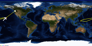
Honolulu to Airport, Honolulu, Oahu, Hawaii
US's FlagHI's Flag

Map
Airport, Honolulu, Oahu, Hawaii:
Latitude: 21° 20' 13" North
Longitude: 157° 55' 2" West
Altitude: 32 feet
From Seattle: 2883 miles
Lodging: Transit - Northwest Flight 946: Honolulu - Seattle

Map
Today's Travel:
Country: United States
Region: Hawaii
Route: Northwest Flight 946: Honolulu - Seattle
Path:Honolulu - Airport, Honolulu, Oahu, Hawaii
Weather: Mostly Sunny / Rain

Click on map to Zoom in...
Map
Trip Stats to Date:
Day: 55
Linear Dist: 13526
Countries Visited: 3
Regions Visited: 9
More stats...
Hotels: 20
Friends / Family: 25
Camping: 6
Transit: 2
Hospital: 2
Beers: 93
Hide...

Journal Entry:
Stacy got up early to watch the ocean and then go meet someone regarding future job possibilities. I went to the post office to mail my lantern home (I thought there was a good chance that it would be denied as carry on and didn't have the room to put it in my checked bags). Also bought a book for the long flight back to Seattle and then hit the internet cafe. When Stacy got back we packed up and headed out to lunch with Uta and Steve - some friends from Pohnpei on their way home. After lunch we caught an early shuttle out to the airport to check our bags and make sure we got seats together. After checking in we still had three hours until it was time to board so we jumped on a bus - in the middle of rush hour it took us nearly an hour to get down there - which gave us just enough time to get ice cream and water before catching a bus back. We waited forty minutes for the bus to show up, and got to the airport just in time to get through security and board the plane.


Paging: [⇚ Aug 5] | [Aug 7 ⇛] OnHiatus.com > Journal 2 > Day Index > Journal Entry: August 6, 2002